blog: Using data to aid public transport recovery
Thursday 25th June 2020
Although lockdown is slowly being relaxed, how people travel around towns and cities will continue to be impacted by Covid-19 mitigation measures. The government is advising people to walk, cycle, or drive for essential journeys, but for many people public transport remains essential. We've taken a closer look at this to understand how well the transport network in Manchester served key workers and what opportunities there are in using data to help plan the recovery of public transport networks.
Assimilating the data
Last month, Transport for Greater Manchester (TfGM) published their public transport network in General Transit Feed Specification (GTFS) format. This feed contains the schedule data for all bus and Metrolink tram services within the Greater Manchester boundary.
To understand how changes to the public transport network during lockdown impacted key workers, we paired the public transport network information with Census data to understand how accessible areas of the city were for healthcare workers.

We did this by extracting information from the Census to understand the geographic spread of key workers across Manchester. As the term 'key worker' wasn’t a common phrase back in 2011 (take a look at the search trend on Google!) we used the “Human health and social work activities” (QS605UK) to find the number of healthcare workers aged 16 - 74. We combined this information with the census dataset on car availability (KS404UK), allowing us to estimate the number of healthcare workers without access to a car.
This allows us to estimate the number of healthcare workers that may need to use public transport if they cannot walk or cycle.
Taking these two census datasets, we paired them with the GTFS feed using Conveyal Analysis to allow us to quickly and easily visualise different transport scenarios based on changes to the network, or for different demographic groups. We often use this to see how vulnerable groups are served differently by the same network (see our recent project in Papua New Guinea!)
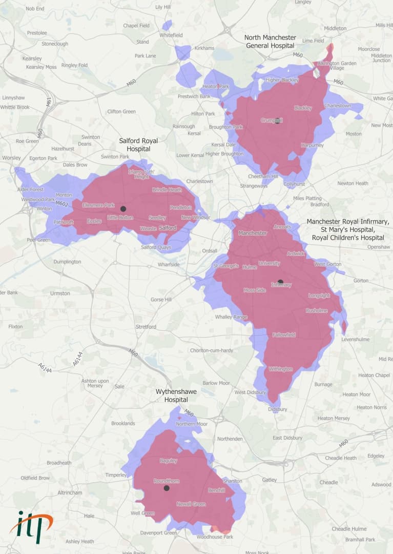
The map below show the differences in public transport accessibility to each hospital in Manchester within 30 minutes, in May 2019 (blue) and May 2020 (red).

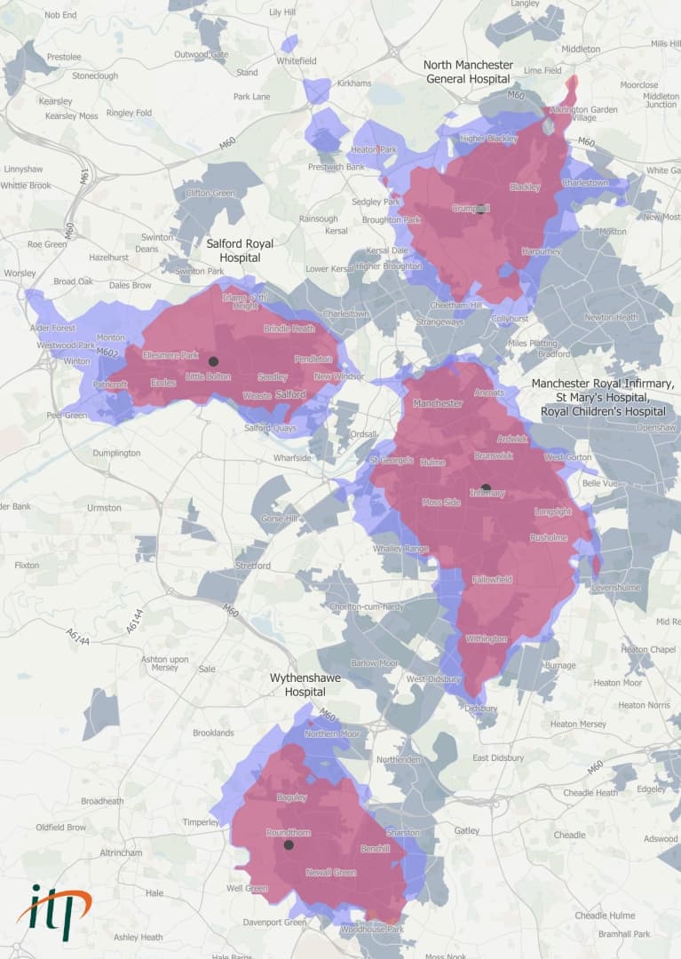
The map below adds the census data to show the top 20% of census areas where health and social workers do not have access to a car (grey).

What does this tell us?
Accessibility is impacted
The first thing is obvious, but it warrants saying, you can’t get as far in 30 minutes today, with the reduced public transport network, as you could this time last year. The census data allows us to quantify this impact by estimating how many fewer health and care workers, without access to a car, are able to reach the four hospitals. We found that public transport access to:
- Manchester Royal Infirmary's site on Oxford Road has been reduced by 23% to 3,550.
- Salford Royal Hospital has been reduced by 30% to 1,450
- Wythenshawe Hospitals has been reduced by 30% to 1,100 workers
- North Manchester General Hospital has been reduced by 50% to 1,100 workers
Evidence-based planning is essential
Secondly, it’s easy to identify areas of opportunity. Imagine, for example, that we want to know where to allocate resources to get as many healthcare staff to work as possible. Most of the health workers near North Manchester General Hospital live to the north, east, and south east so the best results would be achieved by focusing on the services covering Blackley and Harpurhey. In contrast, expanding the service to the north west wouldn’t be the best use of resources as the concentration of health workers is lower there, or there is higher car ownership meaning people do not need public transport to get to work.
Concentrate services in high density areas
Finally, public transport is more effective closer to the city centre. Again, this is nothing ground-breaking, but the public transport world will be thinking about this a lot as we start to ramp up service in “the new normal”. Looking at our 2019 base scenarios:
- Up to 4,600 health workers who do not have access to a car could reach Manchester Royal Infirmary (1.3 miles from St Peter’s Square) within 30 minutes.
- Over 2,100 could reach North Manchester General Hospital and 2,100 could reach Salford Royal Hospital – both approximately 3 miles from St Peter’s.
- Wythenshawe Hospital, which is 6.5 miles from St Peter’s, was within 30 minutes of 1,560 workers.
While the main factors in this are the layout of the city and the exact details of the transport network, it’s a good illustration of how public transport runs better when population densities are higher.
Why is this important now?
Public transport is a vital part of the country’s infrastructure and operators have worked really hard to keep services running during lockdown so those who have to get to work, can. Still, the huge reduction in travel has slashed revenues and operators cannot maintain normal levels of service on the few fares that remain.
As lockdown is eased, priorities will need to be made to support public transport operations. Investing in the services with the most passengers will benefit the greatest number of people, but will also mean that those living on the outskirts and in rural areas will still be poorly served. Spreading the resources more equally across the whole area could give everyone some degree of access but risks creating a barebones service that, in practice, isn’t frequent enough to be useful to anyone.
The speed and adaptability of our data tools allow us to assess the impact of network changes quickly, while the incorporation of demographic data means we can ensure no vulnerable groups are left behind.

If you would like to talk to us about accessibility modelling or our data tools please contact Jeh Chan.
Source: Contains Transport for Greater Manchester data. Contains OS data © Crown copyright and database right 2020.
